Pozzi di Pozzulu
Not only we find the famous pozzi on the plateau du Cuscionu, but there are also pozzi on the Pozzulu stream source, an ascendant from Prunelli.

Not only we find the famous pozzi on the plateau du Cuscionu, but there are also pozzi on the Pozzulu stream source, an ascendant from Prunelli.
The path that leads there is not so famous, and the place is not overly crowded, as people would head to Pozzi de Bastelica, Ghisoni or Lac de Ninu instead. Let’s head to the Col de Scalella, over the town Tavera. On the mountain pass, between villages Tavera and Bastelica, there is a long path, where we can drive along almost until the end, in an all terrain engine. At the end of the path, we need to find the way – which is not clearly indicated, but thankfully there are some cairns lying around here and there.
We find ourselves on a high altitude very fast, an average of 1600 meters. Down below we spot the Verdanese sheepfolds. We arrive on a first summit that will make us feel like we are on top of everything. In the far distance, the mountain massif Monte d’Oru proudly rises.
More in the back, we can even spot the summit Paglia Orba, on the mountain massif Cintu.
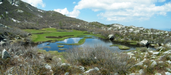
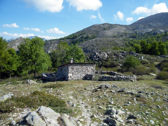
Back on the path, let’s continue the ascent towards the Pozzi. We keep going for a little while, until we reach a sheepfold ruins. These are ruins from the sheepfold Penta. But a house has been wonderfully restaured and even owns a stoned oven in the outside. The way goes towards the moutain massif Rinosu, where there is the Pozzulu stream source. A little wood sign points two paths : To the left, Bucugna, to the right, the mountain pass Vetta. You have to choose the second one. A vetta is a mountain pass which allows to get to the mountain massif and the plateau Rinosu, key step to the famous Frà li Monti (GR20). After 2.30h walking, we eventually get close to the Pozzi. From the sign, there are a lot of cairns, and we even see coloured signs on the rocks. We eventually reach the Pozzi dense grass. The landscape is breathtaking. The map shows that we are at the bottom of the Monte Capanella, which is 2250 meters high. The place is the perfect one for a rest, and even for a pic nic.
We can keep walking as this path leads to the lake Bracca, through the mountain pass Vetta, but we would have to walk from 1h30 to 2h more from the Pozzi. They say that, from there, we could even spot the lake Vitalaca, where there is the stream source of the River Prunelli